Monday, June 23, 2014

Pictograph Trail - Anza-Borrego Desert State Park

We're perched on our favorite mountain ridge, in the Cuyamaca Mountains for a couple of weeks. From where I'm sitting, if I look down and to my right, I can see the Yaqui Well/Tamarisk Grove campground area of Anza-Borrego. If I look behind me, I can see all the way into Mexico. Closer than Mexico though, and also visible, is the Little Blair Valley area. As the crow flies, it is only about 12 miles away. Unfortunately, we aren't crows. So it takes over an hour to get there using a combination of roads.  I don't mind though, because we're almost a mile high in elevation. When we left here it is was about 77 degrees. When we dropped down into the desert, it was HOT and made it up to 104 degrees. It gets MUCH hotter there.

This was taken from our camp site. The little notch just above center is the saddle between Little Blair Valley and Smuggler's Canyon. There is a hiking trail leading up to the saddle and down the other side.
feel free to embiggen photos to enhance your viewing pleasure
This is the view to my right as I'm typing this. Once we got to the bottom of the Banner Grade, we headed towards the horizon. Once we got to the other side of the large mountain (Granite Mt.) to the right. We went right and eventually into Little Blair Valley. 


Down the mountain

Past a dry lake bed

Just about to the bottom of the notch in the first photo. Except for the Border Patrol helicopter that checked us out, we didn't see anther human the whole time we were there. Mad dogs and Englishmen, I suppose...

Looking back towards our campground (on top of the ridge in the middle) from the trail head. 


This is an enlarged and cropped section of the previous photo. Our RV is in the right side of those pine trees on the ridge line. That spot is about 12 miles away and almost a mile higher. Those two little white spots are part of the California Wolf Center which is involved in reintroducing wolves into the state. They have several packs of wolves there and you should hear them all howl. Spooky, beautiful and amazing. If you are ever in the Julian area, it is well worth taking the time to visit.


Geez, that was a lot of writing and photos and we're just now getting to the subject of the post. We're finally up trail a bit. You can still see where we are camped.

Except for hiking in sand and uphill most of the way, this 2-mile out and back trail is pretty easy. However, once you consider all the little side trips I take, looking at things that catch my eye (or because I'm ADD) you can probably add a mile to it.

Looking back down the trail

This is some tough country

Just because I like it.

I'm looking at every peculiar rock for rock art. You never know what you might find.


Coming down the other side of the saddle 

See the large rock at ground level in the distance?


This is that rock!


As is...

Enhanced...


A first glance all the pictos appear to be red.


Looking at the rock closer it looks like there is some yellow present. The dark pictos in this DStretched version are actually yellow. (I'm still a novice).


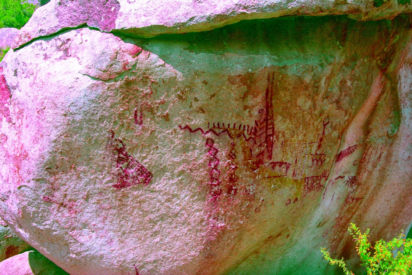
You can see some of the yellow in this one.


Finally! Yellow...


I've never seen yellow (or in this enhanced case brown) diamond chains. There is even an anthropomorphic figure to the left of the sunburst. 


Red and Yellow chains in the same spot. Based on the red diamond chains, this site appears to be (at least in part) related to female puberty initiates. Some of you might remember my earlier post on the subject. 


A lone bedrock mortero at the site. That doesn't mean there aren't many more in the vicinity...


only because I thought it was pretty

Although my Granny was an expert and knew more about Joshua Tree than anybody I've ever met or heard of, she was no slouch when it came to Anza-Borrego. What she loved the most about Anza-Borrego was that until recently, there were very few restrictions relating to where you went and where you camped. She and and my step-granddad, really liked to get away from people. That is very easy to do here because you can camp just about anywhere. Pick a spot on any back country road and you can camp as long as you are a car's length away from the road. It was and pretty much still is wild, beautiful and desolate place.

A bit about Anza-Borrego Desert State Park
Largest desert park in the country
Second largest state park in the country
500 miles of dirt roads (you can camp anywhere, as long as you are a car length away from any dirt road)
Almost 5,000 cultural sites (this is one of them) with only 20% of the park surveyed to date
28 mountain peaks and summits
The world's largest wooden train trestle
12 designated Wilderness areas withing the park


Thursday, June 12, 2014

Hollow Boulder Rock Art Site - Joshua Tree National Park

Here is another hidden and secret rock art site in Joshua Tree National Park. It is one of my favorites. Not because of the amount of rock art there, but because of how cool the spot is. If you don't mind hiking, climbing and finally crawling to get to it. I don't believe there is an official name for this spot and as usual, there was only a few references to it on the internet. None of which included directions to it.

I'll tell you right where it is! It is located in yet another jumbled mass of boulders between two of the thousands of rock formations in the park. (sorry, I couldn't help myself). Most of these places are talked about so little and kept so secret, that it's hard to know enough about it, to even tell if you've found a clue, in something you read or heard. The work really begins once you think you might have an idea where to look.


On another brutally cold day, I'm in Joshua Tree with my traveling companion and wife, who is dressed like "Lawrence, of Antarctica."


After awhile they all start to look the same.


You have to be very careful sticking your head inside of these places. There just might be something waiting for you in there. Probably not though, or maybe just a rattlesnake or mountain lion.


Or even worse, it might be a old creature with a camera, taking a photo of you taking a photo of it.


And then enhancing the photo with DStretch.  Okay, let's get serious.


Because of the isolated location of this spot and the lack of any other habitation clues in the immediate area, this hollow boulder is probably a Shaman's power spot or Shaman's cave. The diamond pattern usually represents a rattlesnake and possibly the Shaman's "helper" animal. As to the tic marks, your guess is as good as mine  In the top of the photo there is a cupule or depression that was somehow used to start fires. How exactly that was done, is another mystery.  If it is a Shaman's cave, the symbols were likely painted while he was in an altered state of consciousnesses and represent what he saw in his "mind's eye."


Same photo after enhancement of the pictographs

In many cases, rake like designs represent rain. I'm not sure if it still represents rain when enclosed in a box, but I'm trying to find out.
Enhanced version

Do these tic marks represent a tally of something? Or maybe the crack in the boulder (when combined with them) completes another rake like rain symbol.


A star or sunburst is always a great thing to find, because the meaning would seem to be obvious.


More snake symbols. Most likely a sidewinder.


This was the only petroglyph we found in the cave.


A better photo of my wife in full-on winter gear.
------------------------------------------
I recently said that I was going to start posting twice a week to get caught up. I did it for a week! I'm just too busy doing things to get posts up about those things I'm busy doing. Figure that sentence out! 

Here is a perfect example...  At this moment we are camped for two weeks on a mountain ridge overlooking Anza-Borrego Desert State Park. We'll be going down the mountain and into AB at least a couple of times. I want to show my wife a couple of the rock art sites (closest to us) and maybe take a look at that bus. We are also very close to Cuyamaca Rancho State Park. You might remember my posts relating to the Stonewall mine, the spot with about 100 bedrock mortars and our hike up a mountain to the site of a hundred year old bi-plane crash (and memorial to it). There is much more to see and report about from there. I almost forgot about the closest spot. It is Lake Cuyamaca. There are also things to do and see around there. These things represent only a fraction of what is easily available to us from where we are. I will easily be able to generate several blog posts on the above items. THAT is why I'm so far behind on my postings.  So please bear with me...


.