Monday, February 29, 2016

Part #1 - Every Long Hike Should Pay Off Like This One Did

Just like the proverbial pot of gold at the end of the rainbow, a recent long hike ended with an amazing reward. 

Several days ago, a friend invited me to do a long hike with him to a place he had just found in the desert. Ignoring my doctor's advice (to do nothing strenuous for six months), I of course accepted. 

This site was so amazing, and so pristine, that I will not be uttering either a name, or location relating to it. After several miles (uphill, I might add), we spotted some large rock formations that were not visible during the entire hike.

We climbed one of the rock piles and then dropped down into a hole. What I saw not only rendered me speechless, it also took my breath away. 


 The thing that blew my mind is the circle of rocks, that is just right of center, at the bottom.


At first sight most people would think that it's a fire ring. They wouldn't notice that many of the stones were placed in a vertical fashion, rather than just being stacked. They also wouldn't think much of the grassy dried vegetation at the bottom (probably a rat nest), or the branch leaning against the inside of it. 


This isn't a fire ring at all. It is an "Olla Nest." The branch (what is left of it) is a "Spirit Stick" and the grass is there to make sure the "Olla" sits on something soft. So what is an Olla?

The large piece of pottery standing next to this lady (her name is Rose), is an Olla.
CREDIT: San Diego History Center

An olla is a large piece of pottery used to store water or food. Because it was high up in the rocks, I'm thinking it was probably used to store food, rather that water. Just a thought. The olla was gone, but that didn't matter. It was awesome just to see the nest.

This little spot was in amazing enough in it's own right, but there is much more!
----------------------------------------


We went up another pile of rocks and once again, had to drop down into an opening.

I apologize about this terribly blurry photo All I can see after dropping into the hole, is another Spirit Stick, leaning up against the rocks. When I got closer I saw...


...that the Spirit Stick was standing right next to a whole Olla. At least it was a whole Olla when it was left there.  Unfortunately, either a rock fell on it, or it just fell apart on its own. Maybe if it had been in a nest! You can't really tell from this photo, but those shards are as large as my hand with spread fingers. Some of them are buried and/or partially buried.  There were also two more Spirit Sticks in there, but somehow I didn't get a photo of them. I don't know exactly how old these two sites are, but they are very old...

My friend knew how much I would love seeing these sites. He was right and I really appreciated it. There aren't very many people who like this stuff as much as we do. There are some of course, but it's a relatively small group.

Part #2 will be posted soon. So much more to see...


.


Monday, February 22, 2016

The Official Center of the World - Desert Oddity

There is no shortage of odd things in the desert and I've shown you many over the years. This desert oddity involves an entire "town" and a whole lot of money. Well, sort of a town anyway. I'll explain as we go.

You are probably wondering what I'm standing on. Or maybe you are really wondering why I have so much scar tissue on my legs.  

 If you were part of the first group, I'm standing on the "Official Center of the World."

The legal and "Official Center of the World" is in the town of Felicity, California. Downtown Felicity is the only part of Felicity there is. The population is exactly two. There is room for more though. Felicity has seven apartments, five of which are vacant (just in case you are interested). As you can see, Felicity (like most things I show you), is in the middle of nowhere. Nowhere in this case, is Imperial County, California,

That is a very nice lawn and tree for being in the middle of the desert. Hey,what the heck is that in lower left hand corner?

What the heck is this doing here? Didn't I do a post titled "Spiral Staircase to Nowhere" about this same thing in Pismo Beach? Actually, it isn't, because this one was once part of the original staircase in the Eiffel Tower. Still though, if you haven't seen it already, you will probably enjoy the other post. 

Have you asked yourself yet, "how in the heck did this thing get from Paris, France, to middle of nowhere desert California?"  If you want actual relevant information about this place, you will have to follow this link.

This is kind of a "you are here" diagram of Felicity. Where we are is just about exactly under the capital "G" in the word granite. 

If you've ever been to the Sistine Chapel, you've probably seen this painted on the ceiling. It is the "Arm of God." When I first saw it, I wasn't sure if it was intended to show us the "way," or direct us to the gift shop to pay our five dollar entrance fee. 

It was pointing to both of those things and more. The gift shop is on the left, "the way" is in the middle, and to the right is where we watched the obligatory five minute video.  

The pyramid contains the "Official Center of the World." As you can imagine, something that important must remain locked up at all times. It will even remain locked up while you are there. However, if you want to cough up a measly five dollar donation, the keeper of the keys will open the door, Then he will let you stand on the exact "Official Center of the World" and even snap a few photos. He will then tell you that there will be an official document waiting for you at the cash register on your way out. The certificate celebrates and documents, the brief moment when you stood on the "Official Center of the World."

Have I said the "Official Center of the World" enough yet?

I made the mistake of calling the "church" on the hill, a chapel. I was told that it is an actual church that holds no services, because nobody shows up. After standing on the "Official Center of the World," we are on our way to the "church." I'll explain all those triangular shaped things in a bit.

 This and the next few photos are just here because I liked them.


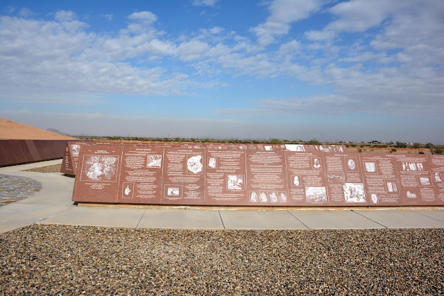
Okay, this is the coolest only cool thing about this place. These large triangular shaped things are covered with solid granite. As this end-piece says, the information etched onto these huge granite panels includes the entire History of Humanity.

 Here are a couple of examples. I wonder where the panel is that relates to trains?


I guess a person could read every panel, but it would take at least a couple of days to do so. I wonder if they'd charge you another five dollars to come back the next day?

I appreciate the dedication that it took to build this place. However, I mostly think it's just one man's extremely obsessive vision. It reminds me of Salvation Mountain and Burro Schmidt's Tunnel. You can follow these links if you so choose.


It just hit me, Where in the heck is my certificate for standing on the "OFFICIAL CENTER OF THE WORLD?"


.

Monday, February 15, 2016

Obscure Rock House Ruins

On our way to Sears Point  a few weeks ago, we passed by the ruins of this lonely looking old rock house. As of yet, I haven't been able to discover a single fact about this place. I guess it's just another reminder that these were tough, strong, and creative people who lived in our deserts generations ago.


Not a store, a doctor, or anything else in any direction for many miles. When I say that, I'm talking about today. Imagine how isolated it was 100 or more years ago.


A whole bunch of skill went into making this place. I know this view doesn't look like much to most people, but to them, I'm sure it was beautiful.


They built themselves a nice fire place. 


An old ruin, an abandoned wreck of an old car, or even an old rusted can. I know it's not much to some people, but to me, it is history in it's purest form. Somebody came here from somewhere else and made something out of nothing. They actually lived their lives out here on the perimeter,  What happened after that? These places fill my head with questions. 

There are people I know who are VERY reluctant to even drive across the desert today. What kind of chutzpah did it take to drop anchor and live out here in the middle of it?  


.

Monday, February 8, 2016

The Old Plank Road


Although they may look like it, these photos were not taken in the Sahara Desert. We were skirting the Mexico/U.S. border on our way to Yuma, Arizona. This 40 mile stretch of paradise is called either the Imperial Sand Dunes, or Los Algodones Sand Dunes. As if that isn't harsh enough, they are sitting in the middle of the Sonoran Desert. I'm not complaining though. After all, we have nice roads to get us through here.

 Like this one...

Even with the wind blowing sand hard enough to take your paint off. I'm still not complaining. We could be driving on...

 This!

Oh yes, now that road would be some smooth driving... NOT! 

Although there was a crummy road going through the desert, until 1914 there wasn't any way to get through these dunes. That is the year a seven mile wooden plank road was laid out across the worst of the dunes. It was a constant battle to keep it from being buried by the shifting sands. The road was used until 1927, when it was replaced by a paved road. Imagine just you and your Model T Ford crawling your way across the desert. Oh yeah, it's about 112 degrees, and you don't have air conditioning.  Now that would be an adventure!   NOT! People really were made of tougher stuff back then. 

Unfortunately, this is the last surviving bit of the old plank road. 


.


Monday, February 1, 2016

Sears Point Archaeological District - Arizona

Sears Point is one of the major archaeological sites in the United States. There are thousands of petroglyphs, as well as geoglyphs, rock circles, grinding areas, ancient trails and rock alignments. This post doesn't come anywhere near doing the site justice. I hate to say that, but we had to make it a short visit because of the weather.

The site is located at the convergence of several washes and becomes almost impossible to get into, or out of. I had enough stuff in our Jeep that would allow us to be stranded there for a day or two, but our diabetic cat back at the RV, would be needing an injection that night. So we were also prepared to hike out (really didn't want to do that). So few people go this spot, that we weren't expecting any help to come along either. We hadn't been there very long when we saw storm clouds coming towards us. That was our cue to leave.


The BLM (Bureau of Land Management) advises visitors to not even try to get to Sears Point during of after periods of rain. It had already been raining on and off for two days and it was expected again on the day after we were there. As you can see in this photo, the forecast was correct (and we went anyway).


Off the highway and onto a maintained dirt road for about 12 miles. Looks like it's clearing up! 


Then we hit the "un-maintained" dirt road and had to battle this for the next several miles. Even with FWD it was very difficult and we almost got stuck several times. It's worse that it looks. The salt content of the dirt in this area is extreme and it makes the mud very slick and stick like glue. Unfortunately, there were very few spots (like this one) to go around the mud.


 You can see what I mean about that salty mud. It made our tires act is if they were totally bald.


Enlarge this photo please
One of MANY fantastic groupings of petroglyphs. This area has been a major "thoroughfare" and meeting place for thousands of years. If you enlarge the photo, you can clearly see where symbols have been made over older symbols.


What follow are a few of the images we saw.


My wife is standing on top of a lava mesa very much like the one in the background. The petroglyphs are along the base and sides them.


Please enlarge this photo!
Looking in this direction, there are a few items that are every bit as interesting and important as the petroglyphs. If you enlarge the photo you will see a rock circle just above center. Next to the circle is an ancient trail, areas cleared of rocks, and some rock alignments. The circle might be some type of a trail shrine (just a guess, based on how close it is to the trail).

 A cleared circle on top of a butte

 Another (of many) ancient trails


One of many rock circles in the area

We will return to this great site as soon as we can!
-------------------------------------------------------------

I would be remiss if I didn't advise you NOT go to this place, unless you have FWD, are prepared to be stuck there for a while, and the ability to hike out. Although it is a "public" site, it is rarely visited and therefore still fairly pristine.  The summer is brutally hot here, the winters can get very cold, and the other seasons can be very cold at night. If possible travel with another vehicle. If you do go, please leave everything as you found it.