Showing posts with label scenery. Show all posts

Tuesday, May 15, 2018

Red Rock National Conservation Area - Scenery - Las Vegas Nevada

As some of you already know we've been in Nevada and Utah for about a month. We stopped in Las Vegas (outskirts) for a week and saw some great things while there. We never went to the strip, or downtown area even once! This place is actually right next to Las Vegas. I'm sure most folks that go to Las Vegas have never seen or heard of it. This is the first post from our time in the LV area. It is all scenery.


From the road it looked like we were going to love this place.

Embiggen please!
If you enlarge anything, enlarge this! The photo doesn't show how large these things are. Also, near the bottom and middle of the photo there are two people standing. They help give the place some scale.


.

Monday, November 14, 2016

Passing Through Sedona

I apologize for the length of time since my last post. I received several emails asking if I was okay. That is understandable with the health issues I've had. I assure you all that I am doing great! The delay was more about logistics (and laziness) than anything else. We've been in Arizona quite a bit lately and most of the time had little or no cell phone signal, which also means no internet. 
------------------------------------------------------------------------------------
We were recently in the Verde Valley area of Arizona. It is pretty close to both Flagstaff and Sedona. We had to pass through Sedona to get there. Passing through Sedona is always a pleasure, because it is one of the most amazingly gorgeous areas in the world. 

I've been to Sedona several times and the first glimpse of the scenery surrounding the town literally takes my breath away.


Without the tourists, Sedona has a population of about 10 thousand. You really wouldn't know though, because there are such strict restrictions on everything that is built there. It must be low, and painted with earth-tones.

Image this being your view while commuting to work. 

Or setting your trash cans out.


 Don't get me wrong, I'd rather there was ZERO development here, but it's a little late for that. There are several "power spots" around Sedona. They call them "vortexes." Yep, I don't think that is the proper plural term for "vortex" either.


Sedona is an artist/zen/new world/counter culture type of place. Not nearly as much as before though. I'll shut up now.


This was taken from a vortex site. I really did feel something there! Of course, it could have just been an LSD flashback.


--------------------------------------------
For as long as we were in the area, we didn't spend much time in Sedona. Hope you enjoyed the photos. A photo really doesn't do the scenery justice.  I'll have another post soon (I promise!). Did a lot of hiking and exploring, and have plenty of potential posts in mind. 

.

Wednesday, October 26, 2011

Southern Utah Jeep Trek

As you know, a few weeks ago we took a roadie to Northern Arizona and Southern Utah.  During our stay we took a few back road/no road treks. In my last jeep based blog post I referred to this trip and said it was a bit scarier.  So, I'll just start this post with the scary part.   (the best pic of this post is the last one, but I hope you look at the entire post)

The other side of the jeep is very close to a sheer cliff. You can see for yourself how far this side is from the a drop off that was at least 100 feet straight down.

This is before the road got really narrow. Same drop off here, but the road was a bit wider.  My wife was afraid to ride in the jeep while we passed through here, so I had her take a photo. Just kidding. She was driving. We usually split up our RV and/or jeep driving.  I wasn't afraid, honest!  As far as the road goes, this was actually the smoothest part.  After this portion...

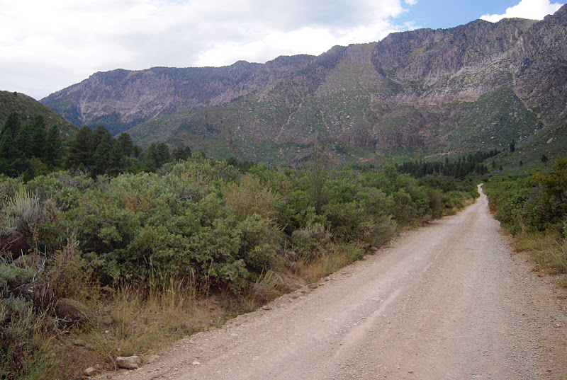
We got to use this "road?" next. I'm not sure I'd call it a road, but at least we didn't have to worry about falling off a cliff. We were on this one for a long time. The rough ride was worth it because it took us to a BLM (bureau of land management) road that was pretty nice.
Our goal was an awesome grove of Oak trees at the base of those mountains. Once we were almost there, we found a barricade across the road. We weren't too happy that we came all that way for nothing. Oh well, we had a good time getting there.

Okay, enough of that, now for some photos, not taken through a window...

When we got to the barricade, we were at the base of the large grayish mountains in the far background.  For those of you in the Utah area, we started our trek from the small town of Hurricane.


This was my favorite photo of the day


.


Wednesday, January 5, 2011

Laguna (south of Broadway)

Although I took the following photos in Laguna, they aren't really related to the storm damage.

Always a fairly common sight around Laguna. First it was hippies and now it's surfers.


Pacific Coast Highway

Skim Boarding  -  The approach

The turn

Drop in

Shred

Walking towards Main Beach and downtown

It's under 60 degrees and this moron is sunbathing! A little bit of the storm surf damage to the right.


She loved the photo, but wasn't happy that I didn't show her new boots. Really? What's the matter with you people?

The view from our table while eating at Olamendi's Mexican food. The land in the background is Catalina Island. It's 30 miles offshore.  The Chicago Cubs used to hold their spring training there.

All of these photos are south of Main Street.  I'll post more of Laguna soon, but next time north of Main Street. Lot's of cliffs in that direction.

.