Showing posts with label Chariot Fire. Show all posts

Monday, August 19, 2013

Fenner, California -- Route 66 Ghost Town

Like many other Route 66 Ghost Towns across the Mojave Desert, Fenner was established (in 1883) as a watering station for steam locomotives operated by the Southern Pacific Railroad.  Other than that fact, there doesn't seem to be anymore information relating to Fenner available.  Fenner of course is the "F" town in the alphabetical naming process conceived by the railroad for this part of the desert. (Amboy, Bristol, Chambless, Danby, Essex, Fenner, Goffs, Homer, Ibis and Java)

I've only heard one story relating to Fenner.  As legend has it, during a national railroad mechanics strike in the 1920's, two scabs (non-union people working during the strike) hired by the Santa Fe RR in Fenner, were kidnapped, taken deep into the desert, made to totally disrobe and left there. This act was to serve as a warning to other scabs, to not take these jobs. Did the two guys live or die? Not only do I not know that, I don't even know if the story is true.

There are no official population estimates of Fenner, but I'm pretty sure that the number is zero.  However, there are a few people around.  One adventurous soul has opened a gas station/cafe in the same area.  Some of you wondered how far people would travel to get their mail at the cute little post office in Essex (from my last post), well this guy does, because Fenner doesn't have a post office.

By the way...
Today's weather forecast for Fenner is... 103F, rain and thunder storms likely.


One thing that Fenner left behind, was the town dump. The good stuff has mostly been buried by the new stuff, but you know that doesn't stop my wife and I from doing some digging.  This tire was taller than I am. I'm sure the rubber content has to be worth a lot. Too bad we couldn't fit it in the jeep.

 Tammy Loves Scummy!

I was afraid to see what (or who) was wrapped up in that black plastic in the middle of the room. I hope it wasn't Tammy!

There is a lot of trash/junk/treasure buried under this dirt. 


 Very old style automotive oil dip stick


Although we didn't find a lot of antique treasures, we did find this airplane wing!  You know what else I found? I found a bunch of medical waste? I don't know if it was legally dumped or not, but it made me quit digging and use about a quart of hand sanitizer. It also had me wondering how long it had been since my last tetanus injection. 


The little building on the left, is probably the ONLY original thing still standing in Fenner.

It seems that half the old pickup trucks and cars ever made are abandoned in the desert. This nice group is just sitting there in Fenner.  A couple of these, especially the car on the right are worth some money, but...

If you look just behind that pick up truck, there is a red antique gas pump, just sitting there!  I promise you that it is worth some good money. The guys from American Pickers would be all over this thing.  Also, look at the building/shack. It might be an original Fenner building attached to an Airstream trailer. I don't know what it is, but it looks like a great example of some fine desert engineering...


Not a tree in sight. Fenner is the little purple spot in the middle. Essex, from last week, is on the very bottom, towards the left. The yellowish line connecting Essex to Fenner is the original National Trails Highway. The NTH was later included in the original alignment of Route 66. Now check this out! Fenner, Goffs (above Fenner) and Homer were not only bypassed by the I-40, they were also bypassed once by Route 66 when the government moved it!  The newer Route 66 alignment goes from Essex (on the bottom) to the same path as the newer I-40.  I hope this confuses you less than it confused me! 


The arrow in the top right corner is the original Fenner dump. The arrow in the middle is point right towards the new gas station and cafe. The arrow pointing up, is point at the old route 66. The yellow lines at the bottom are the Interstate-40.  If you enlarge this photo, you can see the buildings at the old dump. Thanks to Google Maps for the image.
.......................
This week we are back in the area of the Chariot Fire. It has been almost a month since the fire and we have some updates coming for you.


.

Monday, July 22, 2013

Mountain Fire - Riverside County

The Chariot Fire (subject of my last post) was declared out on July 15th at 0600.
Less than 8 hours later, the Mountain Fire started about 50 miles away. As of this moment, the fire is almost five times larger than the Chariot Fire. Thankfully, there has been some rain the last two days (more on the way) and officials with (Cal Fire) believe they will have the fire out by Wednesday. Of course all this rain is a mixed blessing because now there is concern about mudslides and flash floods. Wild fires and mudslides! All we need now is an earthquake to complete the California trifecta. 

In my last post I showed you photos from the Chariot fire. It was south-east from where we were camped. In almost the exact opposite direction (north-west), this is what we saw the same day the Chariot Fire was extinguished.

This photo was taken from our campsite and is 40 to 50 miles away (as the crow flies). It was late in the afternoon and the smoke was almost due west of where I was standing, so I decided to stay there to see what sunset might do to this scene.

Right on cue, the wind died. Rather than spreading out downwind, the smoke just sat there building up into this massive and scary looking cloud. Don't get me wrong, I know the area where this fire was raging and it sickened me, but I still couldn't help feeling a little bit excited about what this monster might look like at sunset, if the wind stays calm. Does anybody else see an evil face in this thing?

Sunset...

The next evening at about the same time. Maybe it's the residual LSD from my formative years, but doesn't the smoke look like a large creature's bulbous head and face laying on it's side?


. 

Monday, July 15, 2013

Chariot Fire - San Diego County

I mentioned in my last post that we were going to our favorite get away spot for a couple of weeks. I also mentioned that there was a large fire in the area and we might have trouble getting there (if at all). Thanks to a change in wind direction we had no problem.

Friday morning we took a chance to see if we could get on the road through the fire area. When we got there, the barricade had just been opened. The scenery was still beautiful for several miles. We decided to make our first stop (to get a view) at a place I did a post on about a year ago. 

Many of these photos were taken in the same spots for both posts. Pre and Post fire...
There was a fireman posted at this spot and he told us that we were the first civilians he had seen there in several days. They were still mopping up the fire and dealing with hot spots and we should be careful. My camera was sending me telepathic messages to get busy. We didn't see another civilian until we had driven all the way through the fire area. We stopped at the little store in Mt. Laguna and on our return trip we saw several civilians, but still not as many as we expected. This is the longest post I've ever done. I apologize in advance for that...

We had just driven through the little town of Julian and our path took us directly towards the fire. The fire was nine miles outside of town. Our campground is about half way there.


A bit closer! I'm surprised the dead bugs on our windshield didn't show up in these two photos.


We made it to our destination and although there was lots of smoke, the fire was now hidden from us.


Here is the just opened turn off through the fire area. We think the guy in the truck just opened the barricades. This took place three days after we arrived in the area.


Beautiful Sunrise Highway (Ca S-1) to Mt. Laguna. No fire damage yet.


One of the "Helispots" for the fire was on a ranch located in this beautiful valley. It was probably the closest place to safely conduct helicopter operations.


Several miles into the drive we saw this. It is almost the exact view from where our RV is parked, but from a different angle.


This is what is left of the old road which was re-routed to the other side of the hills to the right.  On the left side you can see the same monuments in the post from last year. There are plaques on and around it dedicated to hang gliders, some who died there. This path is now part of the Pacific Crest Trail (Mexico to Canada).


They think the fire originated at the bottom of this ravine. I stuck my foot out so you could see just how steep it is.


Just because I liked it

A major rock slide on the old road


The fight goes on in the distance

One of the many Hand Crews we saw in the area.


Another "just because I liked it"


A fireman told me that they believe the fire started where that burnt ground ends in the middle of the photo. It comes to a single point. The prevailing wind blows towards where i was standing, so that is the likely spot.


I took this photo from the Pacific Crest Trail. You can see where it cuts around the top of the burnt mountain top. I'm going to follow the trail for a while.


This is the spot where the trail disappears around the mountain in the previous photo


Around the corner it looks the same and there are more turns to make

Another turn coming up. My goal is to be able to see where we are camped. It's only a few miles and the Pacific Crest Trail goes very close to it.


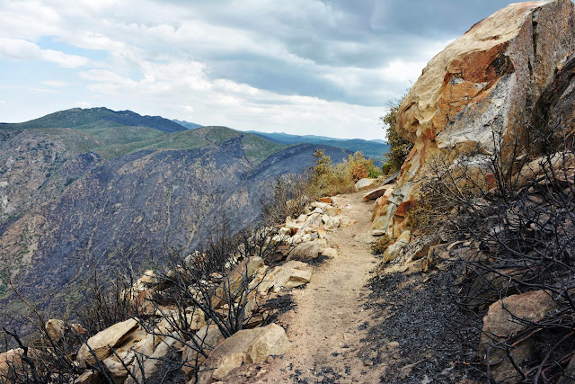
Starting to see a lot of rock on the trail. I think the heat made some of the rocks crack and fall off.


The trail is now covered with ash and burnt material. I know that it isn't healthy to breath this stuff so, I called it a day. Besides, my wife and granddaughter are probably starting to wonder if I've fallen off of the mountain


Heading back down the trail


Just so you can see the scale of it all. It's a long long way down. I'm no daredevil and don't like heights, but this is becoming a tradition, right?


And again...

Back on the road

A very common sight on our drive

One of the main goals for the firefighters was to keep the fire from jumping the road. Most of the structure damage occurred when it did jump the road, from left to right. 


There were 149 structures destroyed in the fire. Many of them in this area.


I have the utmost respect for Firefighters. Especially those who work wildfires. It is brutal, exhausting and extremely dangerous.


This spot is is several miles down the road from where we first stopped. The Pacific Crest Trail is just on the other side of these trees. I don't know what to make of all these fire hoses. Maybe damaged?


Another little hot spot right off the road
The good news is that nobody was seriously injured in this fire!

Last May I did some hiking in this area looking for the remains of an old gold mine town. I didn't know that what was left of it disappeared in an previous fire. I found the place, but not much was left. I did manage to get myself lost though! These things will be the subject of a future post.

.


.