Showing posts with label Gila River. Show all posts

Monday, April 30, 2018

Rocky Point Petroglyph Site - Gila River Area AZ

Rocky Point is another great site along the Gila River. Background info relating to this site, is pretty much the same as my recent post on the Painted Rock site. For thousands of years people have been using the areas around the Gila as an ancient "freeway." While doing so they left a great deal of evidence of their presence.  This site contains petroglyphs, pottery shards, rock alignments, ancient trails, etc. There is also some historic graffiti here.

This photo and the next are in the general area, but may or may not be near the actual site.


 Most certainly a very barren and unforgiving area. 

If you look just left of  center in this photo, you can see a horizontal line of rocks. 

This is the same line, only with the photo taken from above. If you saw it in person it is recognizable as a man made stone wall. Maybe it was defensive in nature, or maybe not...


 The bare line leading away from this is an ancient trail. There is also at least one going up the hill.

 Nature always finds a way.

No idea who left this, but has clearly been here a long time. 

A pretty large pottery shard. There were quite a few of them. (Yes, I replaced it exactly where I found it).


We are spending the next few weeks in Nevada, and Southern Utah, and have already seen some amazing things.

Monday, February 5, 2018

Painted Rock Petroglyph Site - Gila River area AZ

American Indians have lived and traveled through this part of southwestern Arizona for more than 10,000 years. This was primarily made possible because of the Gila River. It flowed freely and fully until about 150 years ago. That was when damming and constant water diversion reduced it to a trickle. Prior to that, the banks of the Gila acted as a "freeway" for ancient Indians. Most of the water may be gone, but the Indians certainly left their mark (literally) on the landscape. This petroglyph site is one of many along the Gila River. Without the river, I doubt there would have been any.

After a long drive across the desert from Yuma, we eventually arrived at our destination.

 This photo was taken from the other side of the rock formation. The ground in the near part of the photo is called "Desert Pavement." It really is as flat and hard as a road, and is a natural occurrence.

 A little closer to this hill of granite and basalt rocks. From this distance you start to see hundreds, if not thousands of petroglyphs.

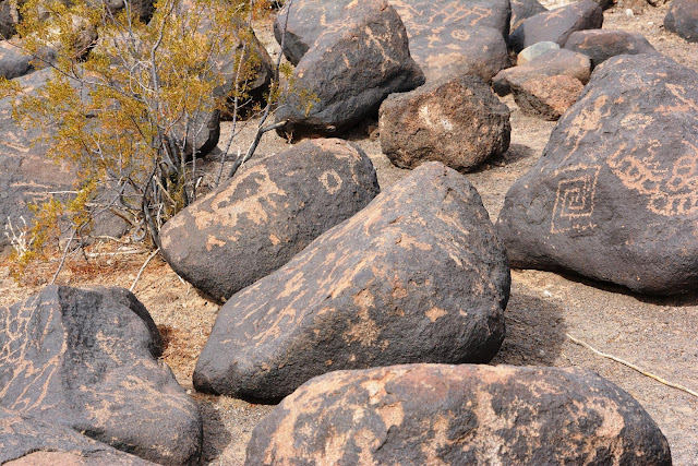
The petroglyphs are primarily of two different styles. The first style is "Western archaic" and were created from approximately 2000 to 8000 years ago. They are mostly geometric in shape. In the middle of the above photo the "grid" shaped symbol is an example.

 The "rake-like" symbol on the rock in this photo is also an example.

The "ladder" looking symbol near the top of this photo is yet another. Just to the right of the "ladder" and and little above it, is a petroglyph representing a scorpion. This is of a different style from a later period.

The second style in the area is called the "Gila Style." Symbols of this style were thought to have been created between 300 BC and 1450 AD, by the Hohokam people. These symbols reflect people, animals, plants, and circular shapes. Some common shapes such as zig-zags were thought be have been used by both groups.


In most places a rock with this many symbols, over such a long period of time, are referred to as "newspaper rock." However, I haven't heard that about this rock. I guess it was a popular place to leave a symbol, because they were made right on top of each other.  There are deer, lizards, people, turtles, spirals, etc.

This is the same rock, but pulled back a bit. You can also clearly see petroglyphs from both styles (and time frames) on the same rock to the right.


This view is pretty interesting for a couple of reasons. First off, you can clearly see that some of the petroglyphs on the top rock are buried in the ground. Nobody really knows how much the ground level changed over thousands of years, but it clearly has changed. The second thing is the "metate" (aka "slick" or "grinding stone").

Here is another metate, this one has a cupule, or small mortar in it. It is a very rare occurrence to see a grinding surface on the same stone that also contains petroglyphs.

I hate seeing graffiti in these places, but sometimes historic graffiti is a good thing. Many other people (non-Indian) later used the ancient Indian trails to travel across the lower southwest for various reasons. Some of these people are famous and you would recognize their names and stories. Fodder for another post, so I won't get into it.  I have no idea who SMC 1815 and Max. G 1857 were yet, but I'm going to try and find out!

TDQ 1878 and VA 1907 were also here. Pretty rude of them to leave their names on the same rock with the petroglyphs. Of course, back then nobody placed any value on them.


Monday, February 15, 2016

Obscure Rock House Ruins

On our way to Sears Point  a few weeks ago, we passed by the ruins of this lonely looking old rock house. As of yet, I haven't been able to discover a single fact about this place. I guess it's just another reminder that these were tough, strong, and creative people who lived in our deserts generations ago.


Not a store, a doctor, or anything else in any direction for many miles. When I say that, I'm talking about today. Imagine how isolated it was 100 or more years ago.


A whole bunch of skill went into making this place. I know this view doesn't look like much to most people, but to them, I'm sure it was beautiful.


They built themselves a nice fire place. 


An old ruin, an abandoned wreck of an old car, or even an old rusted can. I know it's not much to some people, but to me, it is history in it's purest form. Somebody came here from somewhere else and made something out of nothing. They actually lived their lives out here on the perimeter,  What happened after that? These places fill my head with questions. 

There are people I know who are VERY reluctant to even drive across the desert today. What kind of chutzpah did it take to drop anchor and live out here in the middle of it?  


.

Monday, February 1, 2016

Sears Point Archaeological District - Arizona

Sears Point is one of the major archaeological sites in the United States. There are thousands of petroglyphs, as well as geoglyphs, rock circles, grinding areas, ancient trails and rock alignments. This post doesn't come anywhere near doing the site justice. I hate to say that, but we had to make it a short visit because of the weather.

The site is located at the convergence of several washes and becomes almost impossible to get into, or out of. I had enough stuff in our Jeep that would allow us to be stranded there for a day or two, but our diabetic cat back at the RV, would be needing an injection that night. So we were also prepared to hike out (really didn't want to do that). So few people go this spot, that we weren't expecting any help to come along either. We hadn't been there very long when we saw storm clouds coming towards us. That was our cue to leave.


The BLM (Bureau of Land Management) advises visitors to not even try to get to Sears Point during of after periods of rain. It had already been raining on and off for two days and it was expected again on the day after we were there. As you can see in this photo, the forecast was correct (and we went anyway).


Off the highway and onto a maintained dirt road for about 12 miles. Looks like it's clearing up! 


Then we hit the "un-maintained" dirt road and had to battle this for the next several miles. Even with FWD it was very difficult and we almost got stuck several times. It's worse that it looks. The salt content of the dirt in this area is extreme and it makes the mud very slick and stick like glue. Unfortunately, there were very few spots (like this one) to go around the mud.


 You can see what I mean about that salty mud. It made our tires act is if they were totally bald.


Enlarge this photo please
One of MANY fantastic groupings of petroglyphs. This area has been a major "thoroughfare" and meeting place for thousands of years. If you enlarge the photo, you can clearly see where symbols have been made over older symbols.


What follow are a few of the images we saw.


My wife is standing on top of a lava mesa very much like the one in the background. The petroglyphs are along the base and sides them.


Please enlarge this photo!
Looking in this direction, there are a few items that are every bit as interesting and important as the petroglyphs. If you enlarge the photo you will see a rock circle just above center. Next to the circle is an ancient trail, areas cleared of rocks, and some rock alignments. The circle might be some type of a trail shrine (just a guess, based on how close it is to the trail).

 A cleared circle on top of a butte

 Another (of many) ancient trails


One of many rock circles in the area

We will return to this great site as soon as we can!
-------------------------------------------------------------

I would be remiss if I didn't advise you NOT go to this place, unless you have FWD, are prepared to be stuck there for a while, and the ability to hike out. Although it is a "public" site, it is rarely visited and therefore still fairly pristine.  The summer is brutally hot here, the winters can get very cold, and the other seasons can be very cold at night. If possible travel with another vehicle. If you do go, please leave everything as you found it.