Showing posts with label Hearst Castle. Show all posts

Monday, September 25, 2017

Hearst Castle - Central Coast - San Simeon Ca

For those of you who have never been here, it really is a castle. Some say it was complete folly. Call it what you will, but it is amazing. I won't waste your time with a page full of information about the castle, or relating to William Randolph Hearst and his publishing empire. I will give you a couple of links to those things. Also, do you remember Patty Hearst, and/or the Symbionese Liberation Army? Please don't feel pressured to follow the links! 

Links: Hearst Castle website.  
Wikipedia   
W.R. Hearst (Wikipedia)
Symbionese Liberation Army and Patty Hearst (Wikipedia)
Many more photos are here. Most of them taken in areas not available on the public tours.


La Cuesta Encantada (The Enchanted Castle)
In today's dollars, this place cost more than a half billion dollars to build. It is 90,000 square feet in size, has 56 bedrooms, 61 bathrooms, and 19 entertaining rooms. It also had the largest private zoo in the world, and over 100 acres of gardens. The wharf was built so ships could deliver building materials, and supplies to the site.


In my last post I pointed this place out. It was on the top of a hill in the distance. This is the opposite view. San Simeon Point is the land form in the upper right hand corner of this photo. The trail I was on, starts from the wharf (to the right of this golden lady's head), continues around the bay to the actual point, and then around the other side. The very little town of San Simeon was to the right of the wharf. Hearst built the wharf, the town, and planted every tree in sight. The castle is large enough to have 11 different tours available.


The golden lady is to the left of the stairs.


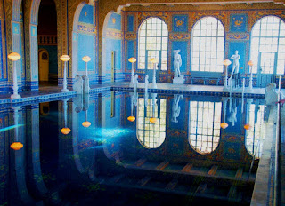
The Neptune Pool. 
One of the tour guides told me that people currently working here, are allowed to use this pool on "special" occasions. The pool is a bit over the top for my liking, but it sure is beautiful. There are many alabaster statues and sculptures around the property. Most of these photos were taken in the middle of the day, with very challenging lighting.  If you want really good photos of this place, there are probably a million of them you can access on Google. I'm sure I have better photos to replace some of these, but I can't find them.


Taken at distance with my phone. Not making excuses, just telling you why it sucks!


My favorite photo of the whole batch. It's peeking at us.

Ready, Aim...

Just because some people don't believe that woodpeckers like palm trees.


Stellar Jay
Pretty common in the west


.

Wednesday, August 30, 2017

San Simeon Point Trail - California Central Coast

In addition to Moonstone Beach and Cambria (my last post), there are many more amazing things to see and experience along Hwy 1 (pacific coast highway). One of those things is the San Simeon Point Trail. Despite being right across the highway from the visitor center for the William Randolph Hearst Castle, this great trail is rarely visited. 
 The trail, pier, and what is left of the little town of San Simeon, is now part of W.R. Hearst SP.

Taken from the trail, this photo shows the little state park. Hearst Castle can also be seen in the upper left hand corner. If you are ever in this area, you MUST see the castle. 


From the parking lot, you turn right at the base of the wharf. 

 At this point, the trail leaves the beach

 obligatory b&w

Sometimes the trail gets a bit close to the cliff edge

and sometimes the trail erodes down the cliff


 at the point

 around the point


Initially, I couldn't see the steer on the right, and for a very tense second or two, I totally thought the one on the left was a bear! 


  • About four miles north on hwy 1, is the Piedras Blancas Elephant Seal Rookery. Older posts here.
  • About one mile further on hwy 1, is Piedras Blancas Light House.
  • Hearst Castle is right across the road (hwy 1). I will post something on this place soon.
  • About 7 miles south on hwy 1, is Moonstone Beach/Cambria (from my last post).
  • Morro Bay/Morro Rock is about 30 miles south on hwy 1) also a must see. Old post here.
  • The 150 mile coastline from here to Monterey is gorgeous. Further, the 25.-30 mile stretch in the Big Sur area, is quite possibly the most beautiful and rugged coastline in the country (if not the world). At this moment hwy 1 is closed in the Big Sur area due to a major landslide.

.

Monday, October 7, 2013

Spooner's Cove - California Central Coast

A couple of weeks ago we spent some time on the central California coast. One day we were looking for a place called Los Osos Oaks (The Bears Oaks) to do some hiking. As sometimes happens, the trail-head wasn't where our GPS said it was supposed to be. So we kept driving.


Instead of what we were looking for, we saw this. We both love the ocean, so we quickly forgot about our hike through the forest.


This photo was taken in front of the white building in the left side of the above photo.  Apparently, we had entered Montana de Oro (Mountain of Gold) State Park without knowing it. I'd heard of the place, but knew nothing about it. Anyway, this old wooden building (now a little museum) was once the ranch house for the 7,000 acre Spooner Ranch. This photo also shows the north side of Spooner's Cove. There is a lot of other history associated with this place, but I think this is enough for now.


Here is the southern side of Spooner's Cove.

This is the right side of the cove again. A lady working in the ranch house told me that there was a major archaeology dig on top of the hill. I saw a trail going up that way and knew we'd be checking it out. The lady then said that there was nothing left up there. Too bad! We settled for sniffing out some sea glass on the beach.


A nice little natural arch.

I'm sure that dog was supposed to be on a leash, or maybe not there at all. Still, it made for a nice photo.

You can see the ranch house on the very left hand side of the photo. That sharp point jutting out into the cove (on the left), is the end of the south side of Spooner's Cove (from the third photo).  The ranch (and now the park) has over six miles of ocean front. Most of it consisting of beautiful and rugged coves.


The scene in the last photo, was directly behind me.  This is the foundation of a storage building that was used to store crops, lumber and sheep products over a hundred years ago.


before being dropped in this gravity chute, which ended at a freight loading area for...


The ships that would dock at the edge of this rocky outcropping.


I was only being stupid here to show you how steep and far down it was to the ships. The actual trail is about 10 yards behind me.

A photo of the cove from way back in the day.
I'll shut up for a while now.


We found a way down into this one.


Each of these layers was the sea floor at some time in the distant past.


For those who have heard of it, that is Morro Rock in the distance (in front of the mountains)


This part of the trail is roped off, but that doesn't stop some people! Like my wife...


If you are ever in this area, I strongly advise you to come and see this place. There are also many great hiking trails in the area.


.