Monday, March 17, 2014

Boriana Mine (abandoned) - Hualapai Mountains - Yucca, Arizona

First off, I apologize in advance for my TERRIBLE proof reading. I just now corrected a ton of errors in this post. 
----------------------------------------------------------
Last week we were once again in the (Ghost) town of Yucca, Arizona (more on that in a later post).

A very nice young lady working at the little market on the Golf Ball House property told us about an old abandoned mine up in the mountains. Not too many minutes later, we were headed there. I have to admit that it was pretty hairy in parts and we weren't sure if we were going to make it without breaking something. The only way to make it up that road is to have high clearance and four-wheel drive. If we had broken down, we had everything we needed for the long hike out of there. You should always have a second vehicle on a trek like this. Of course we didn't, but as mom and dad always said, "do as I say, not as I do...

The primary production years of the mine were from 1915 to 1943. The mine produced Tungsten, Copper and Gold (in that order). It seems to have been quite an operation in it's day and there were at least a dozen out-buildings in the area. 
Then
 (photo courtesy of: Library of Congress and Wikipedia)

NOW
Our little trek originated pretty close to the base of that far mountain range. As you can see, the mine is in ruins. When I took this photo, I was standing on a HUGE mound of mine tailings.  


We are just a couple of miles off the I-40 here and were pretty happy to see what a great dirt road this was. 


 As usual, that nice road didn't last long.

 The road was deteriorating rapidly.


 This was not a very reassuring sight.


Yep, there are people actually living out there. "There" is in the middle of nowhere. I think this stuff belongs to some miners. That little blue trailer is an old classic. 


 Not much of a road anymore


You can tell by the wildly swinging "no headache" charm hanging from the rear view mirror, that this is not a smooth ride.

This is where we considered getting out of the jeep and hiking the rest of the way. We didn't, but only because we thought we were pretty close by then.

At last! After about 14 miles of that road we spotted our destination. All of that orange/yellow and grayish material is mine tailings.


 The obligatory abandoned vehicles


 A lot of old equipment was just left here to deteriorate.

 One of the few, still standing (sort of) structures around the mine.


 This was on the drive in. Some folks really want to get away from it all. 


A stove and oven, now in it's second career as a target.
----------------------------------------------
While I was looking for info on this mine, I saw an article from the Kingman newspaper advising people to stay off the Boriana Road. Apparently, rescuing people off this road (especially in winter) is a normal occurrence. If we had known about this first, I'm sure we'd have done it anyway.


.

Monday, March 10, 2014

Diamond Solstice Pictograph Site - Joshua Tree National Park

Here is another of my favorite, and fairly unknown pictograph sites in Joshua Tree National Park. It is a favorite because of how awesome it is, and also because of how much work we put into getting to it (most of it needlessly).


As demonstrated by my wife's warmest winter gear, it was below freezing on day one. We had two options to get to our objective. Go through this overgrown and boulder filled canyon, or hike around it.  We decided to finesse and/or bully our way through it. Unfortunately, the canyon was having no part of that.

After a long and protracted battle that had us crawling under and climbing over countless boulders like these, we decided to call it a day. We would return the next day and take the long way in. If you compare my wife's cute little face with the things around her, you can see why we stopped. It was very late in the day and we were unprepared to spend the night in the park. There was also the matter of our diabetic travel buddy (Newman the cat), who would be needing his insulin injection that evening. He's a smart cat, but he hasn't figured out how to do it on his own yet.

Bright and early on day two, I came back by myself. 

I left out a lot of the scenery between this spot and where we'd been the day before (I said it's a secret place, right?) Right here I'm looking back down what I had just climbed. Kids, don't try this at home...

This is the overhang that was our objective. If you squint your eyes, you might see something cool in the the middle of the photo. See it?


Here's a little closer look. See it now? 


The overhang had kept these pictographs out of the sun and rain for a long time. I had seen them many decades earlier, but they didn't have the same impact on me then as they did now. I sat under the overhang for quite a while. I ate my lunch and took in the feel of the place. I felt the presence of the ancients who had been there before me, but what I mostly felt was my grandmother. She was the person who first took me here decades earlier. I know I've been promising and I will get a post together about her.


This part of the pictographs really doesn't need much enhancing, but I did it anyway.


This is the summer solstice marker. More on it at the end of the post.

This one is very hard to see.

It looks like a row of tic-marks. I'm not sure of the meaning.

This one needs some enhancing.

I've said many times that we really don't know the meaning of most symbols. This is NOT one of those symbols. When I explain the title, I'll tell you.


The view looking back towards the way I came into this alcove.


Same view, but enhanced, so you can see most of the pictographs in this photo.
------------------------------------------------------------
I haven't seen or heard very much about this location either on the Internet or in books. However, every time I have, it was referred to as the "Diamond Solstice Cave" or "Diamond Solstice Site." I'm no expert, If you remember, I've said that most of the symbols drawn or scratched in the places I've shown you, were either done by a Shaman, or initiates. These diamond symbols were likely painted by initiates, more precisely, "puberty initiates."  I've read things about these red diamond symbols in a couple of places. The following quote is from one of them.

"The final event of the Luiseno Indian puberty celebration consisted of a race, called a "hayie," to a certain rock where a relative of each girl awaited her with a little pot of red ochre paint. On arrival each initiate painted a design on the rock.  Indian informants indicated  that these designs were always diamond-shaped and represented the rattlesnake."  (Dolcie H. Vuncannon)

As with most rock art, there is little in the way of actual proof relating to any of it.  Oh yeah, I almost forgot. In the 14th and 15th photos there is a known symbol that I said I'd explain to those of you who don't know it already. That symbol is called a "Yoni" and has been a part of American Indian rock art for thousands of years. A "yoni" is a female hoo-hoo. The symbol is not really a sexual reference, but one of fertility. 

So is this solstice site, or is it a fertility related site? I may be wrong, but when you combine the red diamonds with the "yoni" in the same small place. I think the answer is pretty clear. Well, as clear as something like this can be anyway. I guess it's both!

During the summer solstice "A finger like pointer of sunlight enters the site to interact with the half circle pictograph with the 14 tally marks sticking up from it." 
If you look at the 9th photo from the end of this post, you will see the half circle that looks like the sun and sun rays. I stand corrected...

If you actually hung around and read all this, I commend you and I thank you...


.


Monday, March 3, 2014

The Ladies of Joshua Tree National Park (no, it's not that kind of post!)

Most people who tour Joshua Tree either do it strictly by auto (which is still beautiful), stop at some of the many "points of interest" pullouts, or walk a couple of the well established nature trails. That is fine, but there are a lot of other great things, that are hidden in plain, or maybe just a little bit off the beaten path. Nobody is going to point them out to you.

Ladies and gentlemen, I present the ladies...


The Red Lady (pictograph)
This is probably the most "famous" pictograph in Joshua Tree. It isn't really hidden, but it might as well be, because very few people see  it. 


 Enhanced photo of the Red Lady. 


The Brunette Lady (pictograph)
The Brunette Lady, is only about a mile from the Red Lady. If you look closely at her hair line, you can see that she is clearly a brunette. 


I have a lot of older photos of this pictograph, but my granddaughter told me that those old photos don't have her in it. So I took her two dollar bribe and said I'd post one with her in it.


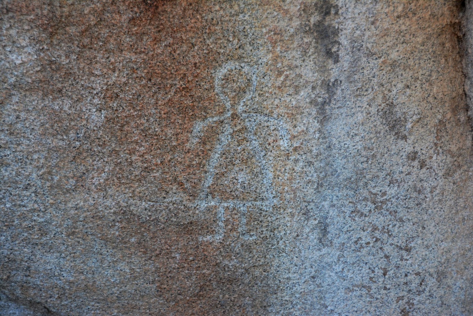
The Modern Lady (Petroglyph)
I understand that "modern" is a relative term when it cones to old things. Still though, isn't this an "A-Line" dress?


The Modern Lady's vandalized twin
It seems that the only difference between this petroglyph and the previous one, is that some idiot followed the lines with a pencil. I have no idea when it was done, but it has been like this as long as I can remember.
-------------------------------------


These last few are just for your viewing pleasure. The don't necessarily have anything at all to do with the ladies. There are from the same area, but that's all I'm saying.
---------------------------------------------
There are a lot more items in these areas, but in deference to the ladies, I didn't want to distract you from their beauty...


.